(Day 26 – September 15) Alamosa to Antonito

odometer: 1621 – 1649 ( 28 miles, 45 kilometers)
elevation: 2360 meters

Today was a short day. I stayed on highway 285 and toiled against a brisk 25 km/hr head wind until I reached Antonito around 1pm.

There are no real stops between Espanola and Antonito. Given the day’s wind condition I knew I could not make Espanola. I took the extra time to reflect and weigh reasons to continue on to Antelope Wells, NM versus returning home from Albuquerque, NM.

These were:

  • There is no good transportation from Antelope Wells. The options are convoluted and costly involving finding shuttles back to a city large enough to have an airport.
  • I had diminishing interest in the terrain. Although the GDMBR would be more interesting it was isolated, dry, and more difficult.  The highways were increasingly monotonous without any real interesting destination.
  • There were events at home that draw me back.

I stayed at a hotel with an interesting southwestern/Mexican flavor. I had my lunch and supper just across the street at a popular restaurant serving Mexican food.   I was amazed that one waitress could handle the till, bus, and serve customers at 10 tables or so.

(Day 25 – September 14) Salida to Alamosa

odometer: 1540 – 1621 ( 81 miles, 130 kilometers )
elevation: 2032 – 2306 meters

The hostel provided a good bed, clean washrooms, and an interesting atmosphere at a good price. I likely am too old to really feel at home in a hostel. They all seem to be run and attended by much more interesting people than me. The hosts all seem a bit artsy/hippy-ish with an unspoken etiquette that I haven’t figured out yet.

I made the decision not to follow the GDMBR. By doing so I avoided having to climb to the summit of the Marshal Pass at over 10,000 feet. Instead I will follow highway 285 to close the border of New Mexico.

Following 285 south out of Salida takes you through the Poncha Pass. At 9,010 feet it was plenty high for me. Believe me.. I won’t regret climbing an additional 1000 feet.

The summits of passes normally are not very scenic. They are generally the lowest point where people can travel through a mountainous obstacle. Typically mountains tower on either side of the pass blocking any possible view of the valleys below.

The approach to the pass can be seen by a break in the tree line – a clearing where there was only incline and trees before. When riding your bike you know the end of hours of toiling is close.

What is really interesting about passes is how they are like gateways. When you pass through them you are often presented with different geography, weather, plants and animals.

The Poncha Pass divided hilly treed land with many streams and creeks with the plateau, the flattest land that I have seen since crossing the prairies. The elevation reading on on my GPS varied only a few meters over 50 miles.

The day was divided accordingly.The morning was consumed by climbing the pass. I had lunch at a nice little cafe in… The remainder of the day I rode across the plateau fighting the headwind.

I arrived in Alamosa just before 7 pm and had supper at an IHop. I will be staying at an old dilapidated motel that I was told is going out of business.All I need is a good night’s sleep – it will fit the bill.


(Day 24 – September 13) Fairplay to Salida


Odometer: 1482-1540 ( 58 miles, 93 kilometers )
Elevation: 3023-2161 meters

Today was another short day. I left Fairplay at 8:30am and arrived in Salida by 1pm. The route was all highway, a net descent, and hills. There was a steady wind from the south east which I had to contend with.

Although by all normal reasoning I should have gone farther today there are choices now of which way to go next and it seemed a good time to rest up and figure out the next steps.

My choices are to take the GDMBR through Marshal Pass or continue along the highway until around the New Mexico border. I consider taking the highway cheating but I am not yet aching to get back to wilderness biking on rough roads and the thought of taking a route up Marshal Pass doesn’t seem like fun. After a good rest I’ll decide tomorrow.

Salida seems like a real town as opposed to others which are more resort towns catering to vacationers. The downtown was vibrant without travelers looking around and milling about with no place to go.

I had lunch at the Boat House which was located beside a stream. Afterward I booked in at the Simple Hostel recommended by a couple I met on the street corner. It is nice to have an adequate option without a high cost. A good rest is all I need.


(Day 23 – September 12) Kremmling to Fairplay

odometer: 1406 – 1482 ( 76 miles, 122 kilometers )
elevation: 2300 – 3023 meters

Kremmling was likely the first town where I ate three meals; lunch at 3pm at a Mexican place, supper at Rockies Bar and Grill and breakfast at the Moose Cafe. All of these places were recommended to me by people who lived in Kremmling. And all of the restaurants served me well with a personal touch. They spoke highly of the other hardworking residents of Kremmling without reserve.

I stayed in the Eaton Hotel. It was an old hotel – likely over 100 years old. The proprietor and his wife purchased the place not so long ago and tended it with love and care. He reminded me of Santa Claus – his voice, mannerisms, genuine hospitality and strong work ethic – all the good that comes to mind when you think of the old fellow. If his beard was whiter I could have been convinced it was St. Nick.

The waitress at the Moose Cafe said that he and his wife were the hardest working folks around. And always ready for a kind talk without politics.

I left Kremmling refreshed. I did nothing but eat and sleep from 3pm on Sunday to about 7am on Monday (today). I was even happy to “sleep in” after being awakened at 4:30am.

I made my way to Silverthorn/Dillon and arrived in good time – just after noon – and had a solid lunch. Silverthorn and Dillon are ski resort towns. There are plenty of restaurants and places to stay along with other touristy trappings.

From my perspective there were two outstanding things the communities provided. One, there a number of bike shops along the route. No detour was necessary. I stopped at one and replaced my chain. My chain had accumulated about 1600 miles and although it hadn’t stretched too much I figured changing it was prudent as a precaution. I didn’t know when I would see another bike shop.

The second outstanding thing about the communities were the bike paths. They were top quality paved paths without the annoying bumps and unevenness often associated with lesser quality paths. They connected the two towns and ran much of the way up toward the Hoosier Pass to the south. (see pictures)

Since it was still early I figured I could make the town of Fairplay in the day. The Hoosier Pass at over 11,542 feet (3,518 meters) was in my way. (BTW – I apologize for mixing units especially to Ann. All my elevation contour lines and GPS readings are in meters. From now on I will attempt to post the net elevation for each day.)

The ascent was tough but satisfying. The scenery was striking. I made the summit by 5pm. From there it was a relatively easy 400 meter descent to Fairplay were I am staying tonight.


(Day 22 – September 11) Steamboat Spring to Kremmling

odometer: 1350 – 1406 ( 56 miles, 90 kilometers )

I was happy to get out of Steamboat. The busy tourist town. In spite of it making a lot of money from the hospitality industry it left an impression that it cared less about customers and people than a lot of other towns I’ve been through.

I set off with either Kremmling or Silverthorn/Dillon as my object. Kremmling was at about the halfway point. Generally if I make the first objective by 3:30pm I continue on to the next town knowing I can make it before dark.

I took highway 40 south out of Steamboat. For the first 6 miles there was a continuous climb  through Rabbit Ears Pass. From there the road followed large rolling hills with a southwest wind which grew to 34 kilometers per hour by the time I reached Kremmling.

I saw several cyclists getting their exercise riding up to the top of the pass and flying back down to Steamboat.

Highway 40 had a very generous shoulder until about 30 miles before Kremmling where it all but disappeared. The traffic was heavy. That along with a strong cross wind made the ride especially stressful and tiring.

I made Kremmling before 3pm. This was good time; time enough to cover the distance to Silverthorn but I was hungry and exhausted. After having lunch I decided to stay the night in Kremmling. It was a quaint town with a quaint hotel; much more to my liking.

img_20160911_171316

(Day 21 – September 10) Little Sandstone Creek Bridge to Steamboat

Odometer: 1277 – 1350 ( 72 miles, 117 kilometers)

The night at Little Sandstone Creek bridge was the coldest yet. I am guessing the temperature dropped to -5. For the first time I had to tighten the top of the sleeping bag over my head to retain heat.

There was cold dry frost on the both the inside and the outside of my tent fly. It flaked off like snow.

The water in my water bottles had partially frozen. I worry now about the plastic cracking if it gets too much colder.

Because of the cold the vapour pressure of the alcohol was not high enough for my flint to work. I tried again and again unsuccessfully to light the stove. I eventually lit it by using a wad of paper towel as a wick bringing the alcohol much closer to the sparks.

My Scandinavian companion had left on his bicycle a good 40 minutes before I finished my breakfast and packed up my tent. When I eventually started I was dressed as warmly as I had ever been. I even put on my woolen socks – which I was happy to put to use.

The day turned out well. It warmed up quickly and I was riding most of the day in my shorts and riding jersey – I had needed my sleeves and gloves for several days previously.

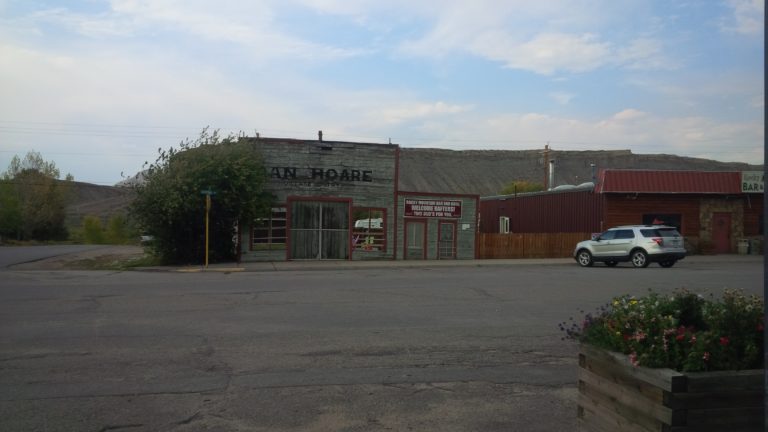
There was a gradual ascent to Columbine, Colorado (not to be confused with the place with the infamous mass murder) which was taxing but strangely easier than yesterday (day 20). I arrived at the general store in Columbine at about 2pm and bought coke, Gatorade, trail mix and an ice cream bar. I struck up a conversation with the proprietor who had just retired from the navy. Since purchasing the place – an old historic general store and adjoining cabins –  he had never worked so hard. Apparently at one time Columbine was a busy gold mining town and was deserted when the gold became easier and cheaper to find elsewhere.

After my short break in Columbine I took the quickest route to Steamboat bypassing the GDMBR tangents which (at this point) I had no patience for.

I arrived in Steamboat in good time (around 4pm) and had dinner at a nice Italian restaurant.

Steamboat is a tourist town. (As the ex-navy officer mentioned – it was named after a hot spring that made a noise like a steamboat. The hot spring has since become silent but the name has stuck.) I don’t get it really. There are more restaurants and hotels in Steamboat than there are people in some places I’ve gone through. There could be 50-100 hotels or motels.

By the time I finished my dinner it was getting dark and I began my search for accommodation. Guess what? I couldn’t find a place in the main town. A lady at one motel which did not have any vacancies was extremely helpful. She suggested a number of ideas, let me use her computer, and even offered to have me set my tent up on her lawn – if I would wait til 10pm.

Eventually I found a place on the mountain as they call it. It was one of many ski resorts on the “mountain”. The lady guided me to a bus which took me and my loaded bike up the mountain in the darkness for free for which I am grateful.

I am now in yet another hotel annoyed that in a town like this I couldn’t find something more appropriate.


(Day 20 – September 9) Rawlins to Little Sandstone Creek

Odometer: 1222 – 1277 ( 55 miles, 89 kilometers )

I took my time getting going and paid the price. I slept in, took my time having breakfast and visited the pharmacy at Walmart.  It was around 10am before I got on the road.

I figured I’d take my time because I had done a big day yesterday (Day 19) and today was only 52 miles.  How hard could it be?

When I got started I took what I thought was the most obvious road to the intersection on the GPS where I needed to join  the GDMBR.   This led very quickly to the four lane interstate which started to make me nervous. I continued however; there was a generous shoulder and another way would have meant retracing my route.

Eventually I came to where the road I needed to take crossed the interstate. Wouldn’t you know it?…there were no ramps. Not only were there no ramps, but barbed wire fences prevented access. I thought for few moments and then did the most expeditious thing. I lifted my bike and panniers over the barbwire, squeezed between the fence and the guardrail and worked my way down the steep embankment to the road below.

And that was the start of the day….

The road out of Rawlins was a steep climb to the south.   It took several hours to complete a fraction of the distance I had covered in an hour the day before.  The day continued with steep ascents and some descents all with a strong cross wind.

Eventually as McCoy had described the dry arid landscape gave way to the aspen forests of the Sierra Madre.   It was like pulling away a veil. Within a few miles it was if you had arrived in another place entirely.  Although the terrain was similarly hilly the valleys were adorned with streams filled with water.   Some how it made the struggle easier and allowed me to forget how slow the progress was.

Any thought I had of doubling McCoy’s distance for the day had long vanished and I had resigned myself to primitive camping just past Little Sandstone Creek.

I arrived at the destination and had set up my tent when a fellow long distance biker from Scandinavia (someplace) came along to share the camp area. I had passed him several miles back struggling to get water from one of the streams.  I told him what I knew, that there was no outhouse as McCoy had described, and the area by the bridge looked promising.

We settled in our separate spots, made supper and retreated to our tents quickly before the sun set.


(Day 19 – September 8) Sweetwater Creek Bridge to Rawlins

Odometer: 1100 – 1222 ( 122 miles, 196 kilometers )

I woke up at about 5:45am to find frost on my tent and frozen water in my water bottles. I am now worried that my filter, which should not be frozen, may not function as it should.   Now I won’t be able to trust the filter alone and will be forced to use water treatment capsules.

The friendly doctors were already up with a fire going. They greeted me and shared some freshly made hot chocolate and some hot water for my oatmeal.   This was a big help because it meant that I did not have to fill and start my stove.

After I had my porridge I packed up all my things and set off.

The road follows the Great Divide and is as remote and desolate as I could imagine.   It leaves an impression that the country is largely unused. One vehicle passes every two or three hours.

The landscape is flat and dry as far as the eye can see. This is up to the distant mountains on each side of the “basin” and to the horizon along it’s length.   The vegetation is dominated by sagebrush. I am still not sure whether the cattle eat this or not.   The bushes are interspersed with grasses and dusty dirt.

Cattle dung is visible every 2 feet or so in various stages of decomposition; some I would guess are many months old.  The doctors, who have a cooking fire every night, had tried to use the dung to burn but they discovered that it smelled very bad.

The day was good again. It was sunny, without much if any cloud, and cool with a very strong westerly wind which I took advantage of.   The only disadvantage was the severe effect of the cross wind whenever the route turned south. Several times the wind pushed my front tire where I did not want it to go.

Wild life was evident again today. Pronghorns and wild horses this time. The horses were just as elusive as the pronghorns and did not allow me to get close enough for a good picture.

McCoy’s day ended at a reservoir  68 miles from Sweetwater. I arrived at the reservoir at about 3 pm and debated about continuing to Rawlins another 56 miles. After having a bit of food and refilling my water bottles I decided to take advantage of the strong westerly winds (which may not come along every day) and continue to Rawlins.   I estimated I would arrive in Rawlins between 7 and 9:30 pm which required lights.

I arrived in Rawlins at 7:30pm tired and shaky from the long ride. I had two hamburgers – one was not enough – and settled into the Holiday Inn Express. I had to do laundry and catch up on the blog while I had the benefit of electric light.


(Day 18 – September 7) Pinedale to Sweetwater Bridge

Odometer: 1005 – 1100 (95 miles, 152 kilometers )

Had a good day cycling.   I followed a dirt road east just out of the town.   The day was similar to September 6 – sunny and cool with favorable winds.

There were no significant ascents or descents but frequent hills and curves. I still made good time and was satisfied with my progress.

The dirt road followed through open ranges without any fencing. Cattle, pronghorn, and coyotes shared the freedom of the open space including the road.

I saw pronghorn frequently.   I never tire of watching them. Their speed is amazing – fast….then…extremely fast. They always seem to have another gear.   I wish I could take a good picture of them but they are very elusive. They seem to take off well before I get close enough on my bike. Perhaps a telephoto lens may come in handy.

Then there were coyotes. I saw two of them running across the road. They seemed fast too but not far off were a group of pronghorns which seemed not in the least concerned. Coyotes, as fast as they are can’t come close to the speed of the pronghorns.

Then there were cattle, sparse.. thinly scattered. Sometimes none could be seen as far as you could see. Other times clumps here and there.   They were not elusive and often stood in the road looking at me with limited understanding as I approached on my bike. Sometimes they would wait until I was 20 feet away before moving, startled.  Then they never seemed to move in the right direction. Dumb things.

At the end of the day I found the primitive camp site at Sweetwater Creek Bridge just as McCoy had described it.     I met up with three doctors who were sharing the camp area. They were from Oxford taking time off to have some adventures. One of them had the next two years of travels planned; including biking through the Himalayas, crewing a yacht on the Atlantic, and racing the GDMBR which he was scoping out.


(Day 17 – September 6) Jackson Hole to Pinedale

Odometer: 926 – 1005 ( 79 miles, 127 kilometers )
As it turns out Jackson is off the GDMBR by about 30 miles to the west. I decided to get back on track by following the highways south to Pinedale rather than retrace my route north to Jackson Lake.

I left Jackson after breakfast and traveled south along the highway beside the Snake River. Jackson has invested heavily in bike paths throughout the city. The bike paths running beside the highway were of top quality, smooth and well maintained.

The day was cool and sunny; excellent for biking.

West of the Snake River valley  a string of mountains are outstanding visually. To the east the hills are not so majestic. They are much closer to Jackson and are a source of recreation in the summer for cyclists and in the winter for skiing.

I followed the highway south along the east side of the Snake River until the Hoback River entered flowing from the east.  At that point another I took another highway running east on the north side of the Hoback River up into the hills.

The day was beautiful aside from the highway travel. I didn’t mind. The winds were favorable, the hills weren’t too bad and I made good time.

I stayed in Pinedale, a small town with not great but adequate services.   By McCoy’s account it is a cowboy town but I didn’t see any cowboys. I had supper at Subway and stayed in a nearby hotel.